Increasing ocean surface temperatures are contributing to more frequent harmful algal blooms (HABs) which are wreaking havoc on the blue economy. Fortunately, NASA will soon deploy a new technology which will drastically advance our ability to monitor, study, and prevent HABs, protecting both the environment and the economy.
The Sea Monster that is Algal Blooms
In 2000, U.S. businesses lost an estimated $49 million due to HABs [4]. Accounting for inflation, that’s more than $74 million in today’s dollars and HABs have only increased in frequency and severity since 2000. These losses stem from the closures of beaches, fisheries and other activities in order to protect the public’s health from the dangerous water quality. In addition to closures, HABs can lead to mass die-offs of marine life which then wash-up on the beaches and create a putrid odor that can be smelled for miles around.
Microalgae, or phytoplankton, are like plants and need sunlight and nutrients to grow. When an excess supply of nutrients becomes available, such as nitrogen or phosphorus from terrestrial runoff, algae will grow rapidly in dense concentrations called blooms. HABs are a unique type of bloom attributed to certain species of microalgae that naturally produce toxins that result in ecosystem damage.
The entirety of contributing factors that cause HABs is uncertain, but there are a few particular factors that seem to be consistent in areas where HABs are observed. These include excess nutrients in the water due to nutrient runoff from fertilizers on land, poor water circulation, and increased ocean surface temperatures. If HABs are dense enough, the algae will actually change the translucency and color of the water, varying in color from reddish-brown to green, depending on the type of algae.
Keeping an Eye out for HABs
Our current abilities to monitor HABs are limited by too few humans, inadequate technology, and limited financial resources to monitor the entirety of the ocean. These limitations are compounded with marine algae’s life cycle, which only lasts 2-6 days [2]—meaning near constant monitoring is required. These issues make management and mitigation of HABs nearly impossible, however a new wavelength sensing technology may offer a solution.
Human eyes distinguish color through cone cells that perceive varying wavelengths of light reflected off surfaces. Optical instruments operate in a similar fashion and can measure a larger spectrum of wavelengths than our own vision. If the HABs are large and dense enough, their color signature can be viewed from space by reading wavelengths reflected off the ocean’s surface. This is exactly what NASA’s new Plankton, Aerosol, Cloud, ocean Environment (PACE) satellite project will attempt to measure using the latest in optical sensor technology.
NASA’s PACE Satellite Project
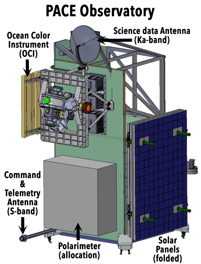
The PACE satellite project, set to launch November 2, 2022, is NASA’s latest and greatest attempt to monitor and identify ocean color. This project is the fifth and most advanced of its kind in a series of projects dating back to 1978 [1]. With each mission, the capability to view more wavelengths of the light spectrum increased, allowing for higher resolution data with each upgrade.
The PACE satellite carries two spectrometers, two multiangle polarimeters, and seven other detector bands. The two spectrometers each detect different parts of the spectrum, one collecting data from Ultra Violet to orange, the other orange to Near Infrared, and the multiangle polarimeters cover this same range (visible spectrum- Near Infrared). The detector bands in the satellite will be used to detect any short waves which help to correct any wavelength interference from particles in the atmosphere.
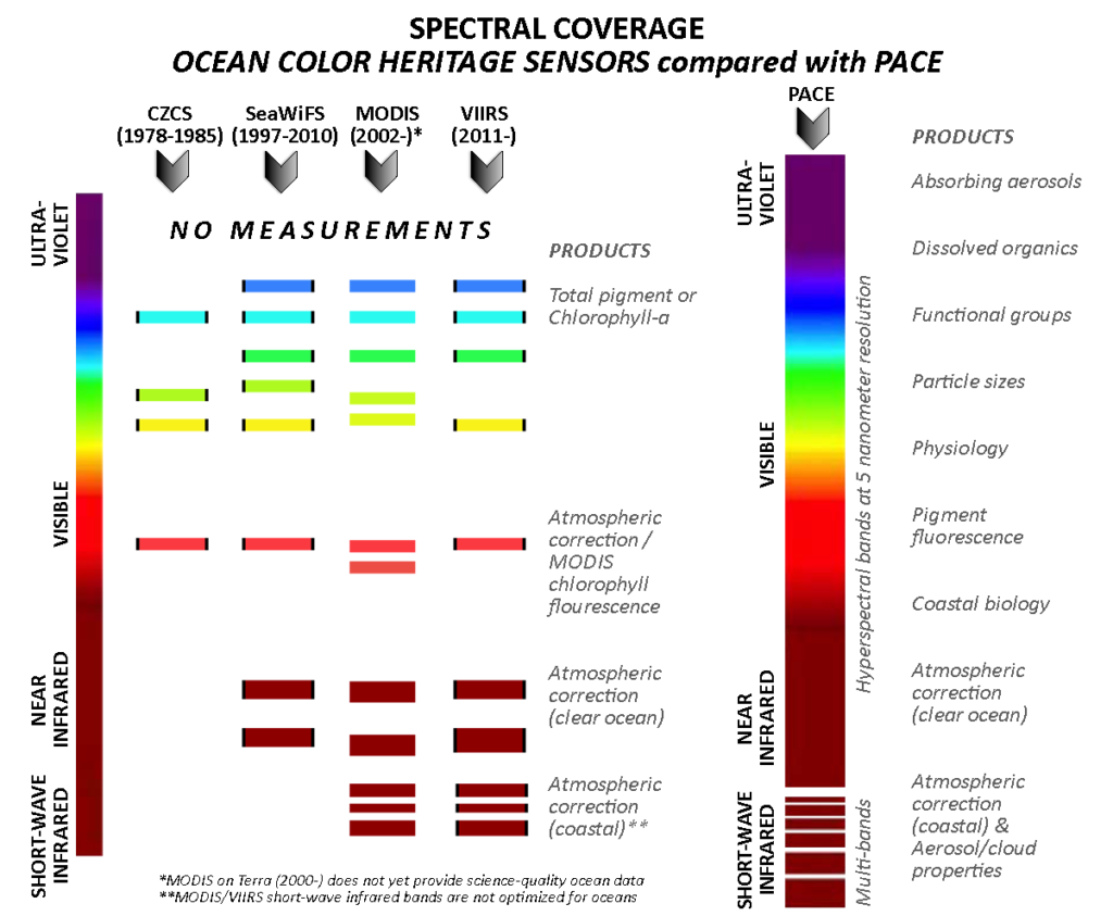
The new visible spectrum data that PACE provides will generate vital knowledge about algal blooms worldwide. Orange and blue wavelengths will be used together to identify specific species of diatoms in phytoplankton blooms through the their unique pigmentation, while green and yellow wavelengths can be used to identify diatom size and nutrient availability in the surface water, respectively.
Impacts of HABs: Monitoring and Prevention
The PACE satellite will be acquiring wavelength data on a continuous basis and streaming it back to scientists. This data paired with surface water temperature, salinity, wind, ocean current, and stratification data sets could potentially reveal patterns of bloom occurrence and identify the composition of these blooms. Using PACE to identify areas of high-pollution from terrestrial runoff and dense algal blooms allows us to better conserve Marine Protected Areas so they are less affected by these issues. In this same way, we might be able to identify locations that show early signs of fish die-offs due to high algae counts and take actions to reduce impacts, such as limiting fishing to lessen the environmental stress on fish.
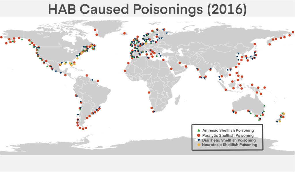
About 45 percent of the total losses from HABs are from expenses acquired by human health issues [4]. Recreational shellfishing and shellfish farming require strict monitoring to prevent outbreak of HAB caused illnesses such as Amnesic Shellfish Poisoning, Paralytic Shellfish Poisoning, Diarrhetic Shellfish Poisoning, and Neurotoxic Shellfish Poisoning (NSP). Most of these poisonings occur due to consumption of an organism that has had contact with HABs, however NSP can affect humans via aerosols pushed into the air through wave and wind action at the ocean’s surface.
To prevent illnesses like these, there are recurring annual closures of shellfish farming, fisheries, and recreational fishing. These affected areas of the economy would widely benefit from HAB data. With the right data from PACE, the shellfish industry could better protect their harvest from HABs just like a farmer relies on their local weather forecast to avoid droughts [3].
Although NASA’s PACE satellite is as far as one can possibly get from the marine environment, the technology will have many benefits to ocean conservation and the blue economy. While it has taken decades of research, development, and deployments of satellites with ocean color sensing technology, we are now within arms reach of their most advanced feat yet: accurate HAB monitoring and prediction.
Citations
[1] NASA PACE – Home. NASA. Accessed January 2021
[2] Werdell, P. et al. (2019). The Plankton, Aerosol, Cloud, ocean Ecosystem (PACE) mission: Status, science, advances. Bulletin of the American Meteorological Society. 100. 10.1175/BAMS-D-18-0056.1.
[3] Schollaert Uz, Stephanie et al. (2019). Developing a Community of Practice for Applied Uses of Future PACE Data to Address Marine Food Security Challenges. Frontiers in Earth Science. 7. 283. 10.3389/feart.2019.00283.
[4] Scientific Committee on Oceanic Research (SCOR) and the Intergovernmental Oceanographic Commission (IOC) of UNESCO (2017). GlobalHAB Science and Implementation Plan
[5] Harmful Algal Blooms. Woods Hole Oceanographic Institute. Accessed January 2021